
Is the Mumbai Coastal Road Worth the Hype? 3 Hidden Viewpoints You Can Only Reach by Car
Now that the northern extension is fully open, travelers can access secluded rocky outcrops and sunset spots that were previously cut off from the city.
The first time I drove through the undersea tunnel of the Mumbai Coastal Road, I forgot I was in India. For exactly 2.07 kilometers, the chaotic honking of rickshaws and the humid scent of the city’s fish markets vanished, replaced by the sterile, futuristic hum of high-speed transit.
In February 2026, the Phase 2 extension of the Dharmveer Swarajya Rakshak Chhatrapati Sambhaji Maharaj Coastal Road was finally inaugurated, completing a vision that has been decades in the making. While the headlines focused on the engineering feat and the slashed commute times between Nariman Point and Kandivali, they missed the real story for travelers. This road isn’t just a bypass; it’s a portal. By opening up the northern extension, the city has inadvertently unlocked access to secluded rocky outcrops and sunset vistas that were previously walled off by dense urban slums and inaccessible shorelines.
If you are landing at BOM (Chhatrapati Shivaji Maharaj International Airport) and heading south, or if you’ve got a long layover and want to see the Arabian Sea without the crushing crowds of Marine Drive, you need to get behind the wheel. You cannot walk these routes, and public transport hasn’t caught up to the interchanges yet. Here is why the Coastal Road is worth the hype, and exactly where to find the viewpoints that aren’t on the tourist maps yet.
The Geometry of the New Mumbai
For years, the Bandra-Worli Sea Link was the undisputed queen of Mumbai’s infrastructure. But the Coastal Road Phase 2 extension changes the city’s geometry. It doesn't just sit on top of the water; it reclaims the relationship between the land and the sea.
When you exit the airport and pick up a vehicle, the old wisdom was to suffer through the Western Express Highway. Now, the savvy move is to cut west as soon as possible. The extension has created a seamless flow that makes the southern tip of the city feel like a twenty-minute hop rather than a two-hour pilgrimage. But the real magic happens at the interchanges—those massive, looping concrete structures that have created "dead zones" where the city's noise can't reach.
Viewpoint 1: The Worli "Slip" Outcrop
Most people know Worli Sea Face. It’s a classic. But Phase 2 has extended the road in a way that creates a "slip" near the northern interchange. As the road elevates to meet the Sea Link, there is a small, paved service area intended for maintenance that has become a de facto sunset spot for those who know how to find it.
To get here, you have to exit the Coastal Road at the Worli interchange and immediately take the first left into the local fishing colony road. You’ll find yourself underneath the massive pillars of the new road. Park the car and walk toward the tetrapods. Because this area was a construction site for the better part of five years, it is pristine. You get a view of the Sea Link from an angle that looks like it’s rising out of the water directly toward you. At night, when the cables are lit, the reflection on the calm water—protected by the new breakwaters—is the best photo op in the city.
Viewpoint 2: The Haji Ali Bay Overlook
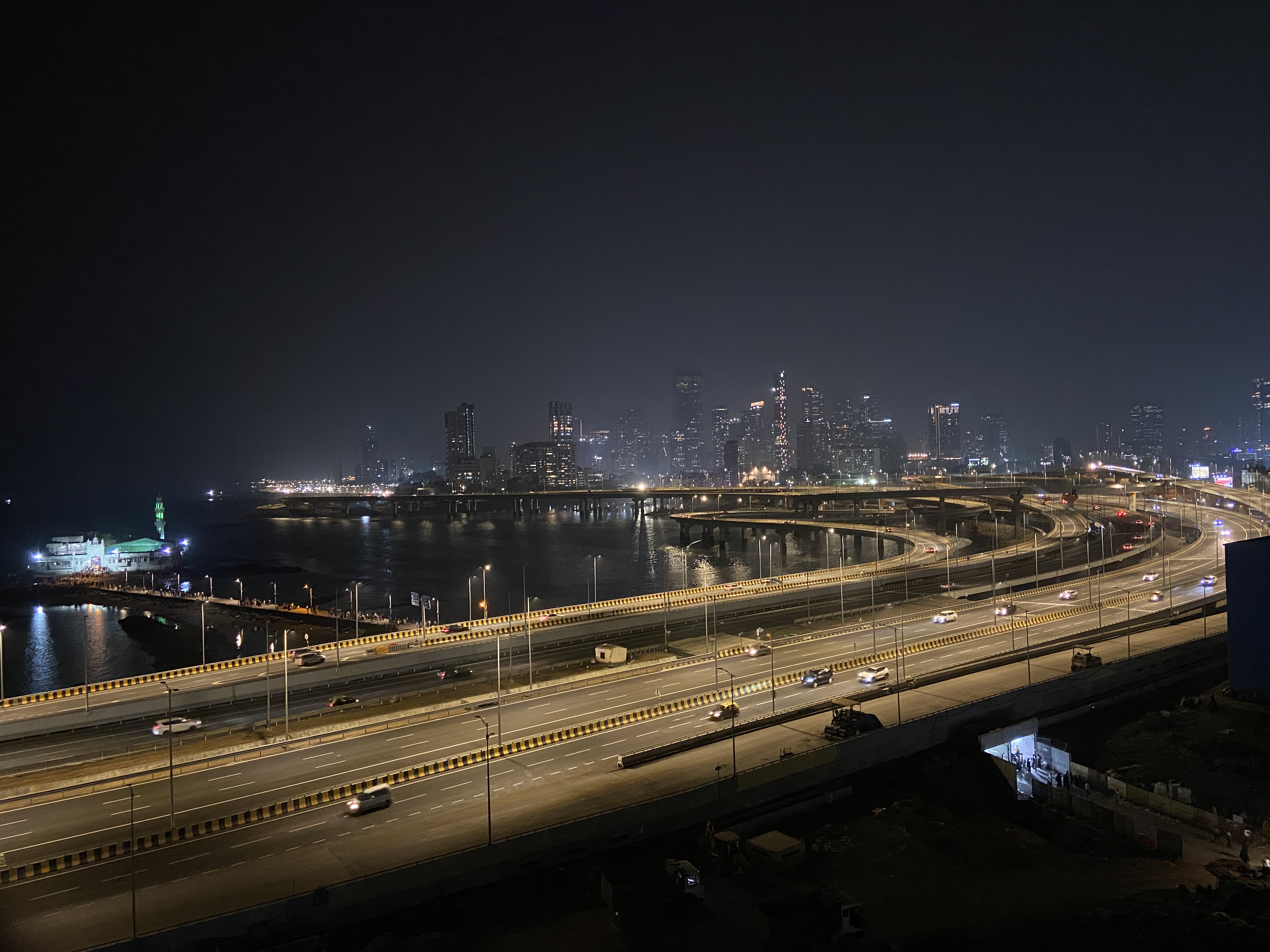
Before Phase 2, Haji Ali was a nightmare of traffic and construction debris. The completion of the northern extension has diverted 70% of the through-traffic, leaving the coastal promenade surprisingly quiet.
The hidden gem here is the elevated bridge section that curves around the mosque. If you are driving south, there is a specific pull-off area just before the tunnel entrance. It was designed for emergency breakdowns, but if you’re quick (and careful), it offers a panoramic view of the Haji Ali Dargah floating in the middle of the bay. You’re high enough to see the entire sweep of the bay back toward Mahalaxmi. It’s the only place in Mumbai where you can see the ancient spirituality of the Dargah contrasted against the hyper-modern glass towers of Upper Worli without a thousand people in your frame.
Viewpoint 3: The Versova Foreshore (The Northern Edge)
This is the newest addition. The Phase 2 extension pushes toward the northern suburbs, cutting through what used to be inaccessible marshland and rocky coast. Near the Versova end of the project, the road runs parallel to a stretch of shoreline that was once cut off by private estates and thick mangroves.
There is a small slip road near the new bridge landing that leads to a rocky plateau. It’s raw, it’s windy, and it smells intensely of salt. From here, you can look south and see the entire silhouette of the Mumbai skyline, from the towers of Prabhadevi all the way down to the tip of Colaba. It feels like looking at a different city—one that is organized, sleek, and oceanic.
The Logistics: Why You Need to Drive Yourself
You cannot experience these spots in a bus, and most Uber drivers will be hesitant to stop on the high-speed sections (and rightfully so, for safety). To really explore the "hidden" side of Phase 2, you need your own wheels.
If you're visiting from out of town, renting a car at BOM is significantly easier than it used to be. The infrastructure around the airport has improved alongside the Coastal Road, making the transition from the terminal to the highway almost seamless.
A counterintuitive tip: Do not drive the Coastal Road during the "Golden Hour" if you are in a rush. Everyone else has the same idea. Instead, drive it at 11:00 PM. The speed limit is strictly 80 km/h (and yes, the cameras are active and the fines will find you), but at night, the undersea tunnel is illuminated in a soft blue light that feels like a scene from Blade Runner. It is the most peaceful experience you can have in a city of 20 million people.
Connectivity and Navigation
The new interchanges are complex. If you miss an exit, you might find yourself five kilometers away before you can turn around. Google Maps is struggling to keep up with the 2026 updates, and signal drops inside the tunnels can be frustrating if you’re relying on a roaming SIM that keeps switching towers.
Before you leave the airport, ensure your data is locked in. I’ve found that using a local India eSIM is the only way to ensure the GPS doesn't lag when you’re navigating the multi-level interchanges at 70 km/h. There is nothing worse than the "recalculating" voice when you’re staring at three different forks in the road.
Is it Worth the Hype?
The Coastal Road isn't just about saving 40 minutes on your way to a meeting in Nariman Point. It has fundamentally changed how Mumbai looks at itself. For the first time, the city is facing the ocean rather than turning its back on it.
The "hype" usually surrounds the commute, but the real value is in the access. We’ve spent decades crowded into the same three kilometers of Marine Drive. Now, the city has ten times that amount of coastline accessible to anyone with a car and a sense of curiosity.
If you’re a frequent flyer who usually just sees Mumbai through the window of a taxi on the way to a hotel, change your routine. Grab a car, hit the Coastal Road, and find those rocky outcrops. The city looks entirely different when you’re standing on a tetrapod at the edge of the northern extension, watching the lights of the Sea Link flicker to life.
And if you’re worried about your flight out of BOM while you’re exploring the coast, keep an eye on PingWing. The traffic on the new road is predictable, but the gates at the airport are not. It’s the perfect pairing for a modern traveler: high-speed roads on the ground and real-time tracking in the air.
Mumbai is finally a coastal city again. Don't miss the view.